Wednesday, September 28, 2011

Warner Hollywood Theater

After my last post, I wanted to continue following the links in the chain and write about the Warner theater on Hollywood blvd. I'm afraid this post might come with more questions than answers.

I wrote in my Hollywood post that Warner was considered one of the big 5 because they owned all three parts necessary for vertical integration. They owned their own studio, their own stars, and their own movie houses. We looked at the one in San Pedro, the Warner Grand, last post, and boy was it pretty. The Warner Hollywood Theater (later Warner Pacific) was the first theater Warner built in the Los Angeles area.

The Warner Grand opened in 1931. The Warner Hollywood opened April 26, 1928, but was conceived of as early as 1925. In an LA Times article, it's mentioned that it will cost $1.5 million to build, will seat 4,000, and will be used for first fun films, before they were sent East.

Photo I took of the Warner Hollywood theater. It has the Pacific signage now, since the renaming. You can see a radio tower at the top. That's gonna come up later. 
So the LAT article mentioned the Warner Hollywood was the first in LA, but the Pantages in Portland was the first on the west coast. Now that made no sense to me, but it allows me to open the door for my next post, the Pantages Vaudeville Theater chain.

Here's what I can't figure out. The LAT article was written in 1925. The theater in Portland was only known as the Pantages from 1927-29. Now that LAT article mentions it's being renovated for reopening. The theater in Portand was the Hippodrome from 1917-1925, then there's the two year renovation gap. I guess the name was already common knowledge.

So the facts are these. Warner Bros. didn't become a major player until the late 20s. That map I showed in my Hollywood post, with all the Hollywood studios relative to the Studio Club. I misread that (like I said, this is my historical journey). Burbank, First National. That's not a bank! I assumed, cause it sounds like a bank. First National was a movie studio, founded in 1917, which merged with Warner Bros. in 1928.

See First National was a theater chain, but they decided to start producing films in 1924. They bought that big lot out in Burbank, that now is the Warner Bros. studio lot. It all makes sense! Warner made a ton of money in 1927 after releasing the first talkie, The Jazz Singer. So they start building theaters, and they merge with First National and suddenly have access to a lot more. That's how WB became one of the Big 5!

So if the Warner Hollywood was finished in April, 1928, that's before the merger with First National. Like I mentioned at the top, it was Warner's first run theater, many premiers were held there. Then the films would be shipped back East. That antenna on top of the building, that was for broadcasting KFWB, the station Sam Warner launched in 1925 and which is still broadcasting today!

Looking down Hollywood blvd, 1930s. You've got the Warner's theater sign, the broadcast tower, and oh so much more. 


The first film shown at the Warner Hollywood was a talking film called Glorious Betsy. Warner called its sound film process Vitaphone - after the merger with First National, all of First National's theaters had to be fitted to show Vitaphone films. Like 3D today, theaters had to modernize to play a sound track during the movie. Amazing.

The Warner Hollywood also gives me a platform to talk about two other things, and use the 3D analogy again. When it was conceived, in the 20s, radio was the big home entertainment, and seen as a companion to, not a competitor with movies. In the 50s, TV was seen as a huge threat to the movie industry, which is when they came out with the widescreen format.

When TV was first launched, it was done in the same box format movies were filmed in at the time. So movies switched to widescreen in order to offer something different, and to prevent TV from being able to show never movies in their original format (anyone with a VHS remembers "this film has been edited to fit your screen") TV was such a novel thing, you couldn't just redesign it, no one would buy a new new TV. Then it just became the way of things, until flatscreen technology made widescreen television readily available. That's why 3D has become so huge, the movies feel they have to constantly differentiate themselves from the home experience. Of course, technology moves so fast now, there are already 3D TVs.

Jumping back to the Warner Hollywood, it was one of the few theaters in Hollywood big enough to fit a widescreen, and actually converted to Cinerama (ooo, there's another post, the Cinerama craze still immortalized in the Cinerama Dome on Sunset). As a result, the Warner was able to keep showing films all the way into the 90s.

So a bit of a jumbled history of a theater in Hollywood. It looks like it's just an old building, but it holds the history of two motion picture companies, film history, radio history, hollywood blvd history, and LA history. This is why I love old buildings.

Wednesday, September 21, 2011

Warner Grand San Pedro

I wanted to hold off on this post until I could get down to 6th st. in San Pedro and see it again for myself, as I never remembered to take pictures when I hung out on 6th st. as a teenager. Not only does 6th boast the oldest bookstore in Los Angeles (the over 100 year old William's Bookstore) but it's got a heck of a movie palace in the Warner Grand Theater.


The Warner Grand opened January 20, 1931. This picture from the Los Angeles public library archives dates from 1931, how cool! The art deco theater was designed by B. Marcus Priteca, and was described by Jack Warner as the "The Castle of Your dreams". It had two sister theaters, the Warner in Beverly Hills and Huntington Park, but it's the only one still standing. I haven't shown you the inside of one of these palaces yet, if you haven't been in one, they're quite fantastic: 


You have to think of these as the transition between the old nickelodeons and and suburban multiplexes. The nickelodeons were named for their admission price, with Odeon being Greek for a roofed theater. They went hand in hand with the short length film which was the mainstay of early movies. Nickelodeons were often multipurpose places, with those hand crank movies you find at main street Disneyland in the lobby as well as screens for short, silent films. Vaudeville theaters would also show short films. 

We've talked here on the blog about that transition from short films to feature length, Cecil B. Demille's barn on Vine St. Feature length films needed to be presented with the seriousness of Broadway Theater, so these ornate, million dollar palaces were built. The screens were massive, so it could be visible from the back of the balcony. There were fears the audiences wouldn't sit around for two hours in the dark, so the goal was to make patrons as comfortable as possible. 

Part of that legitimization also came in the forming of the Academy of Motion Picture Arts and Sciences, and the hosting of the Academy Awards. Mary Pickford, who we talked about last time, was one of the founding members of the Academy. As a bonus, before I sign off today, here's Cecil B. Demille's barn being moved to it's current resting spot, near the Hollywood Bowl as part of the Hollywood Heritage Museum. 


Tuesday, September 20, 2011

Hollywood

I've touched on Hollwood a couple times, so it's probably about time to do a post about the town that's become a synecdoche for Los Angeles. This is only going to scratch the surface, but that's the design of this blog. Scratching away at LA's history.

Important dates have already come up on the blog. Hollywood was consolidated into Los Angels Feb 7, 1910. In January 1910, DW Griffith convinced his bosses at Biograph Pictures in New York that he needed to go to Los Angeles to film an adaptation of Ramona in authentic locations. Ramona used to be a staple in elementary school reading lists: it's about a part Scottish and part Native American orphan girl in Southern California. It gives a sentimental version of Spanish colonial life in California, and for the early part of the century, shaped what East Coasters thought of California. It's influence is seen in the rise of the Western genre. It's also the film that launched Mary Pickford's career, and everyone knows Mary Pickford is awesome. And Canadian!

Mary Pickford, a curly blonde Canadian, dons a native looking wig for Ramona. 


Anyhow, Griffith gets here in Los Angeles, and then here's about this little village called Hollywood. They travelled up and shot another short called In Old California, generally regarded to be the first film of any length shot in Hollywood. Naturally it's another love letter to Spanish colonial California. The East Coasters loved that stuff.

Biograph decided to move to LA permanently, setting up a studio in downtown in 1911. In 1913, Cecil B. DeMille is credited with setting up Hollywood's first major film company studio. He rented a barn at what is now Vine St. between Sunset and Hollywood for $250 a month, then used it to film a Western called The Squaw Man. Made for just $15k, the movie grossed $200k - LA's first big hit.

The old barn was moved to the Paramount Studios lot in the 20s, and was even used as part of the Bonanza set. But I'm getting ahead of myself. The Squaw Man was released by Famous Players Film Company, again a New York racket, who boasted established theater stars as their calling card. "Famous Players in Famous Plays".

Famous Players opened a studio at 5300 Melrose in 1915, one of the oldest studios in Hollywood. Of course, Famous Players, through some mergers and whatnot, became Paramount Pictures, whose studio still stands at 5500 Melrose today.

Paramount's Melrose entrance. 
Fast forward to the 1920s. In 1923 Harry Chandler erected a sign reading "Hollywoodland" to advertise his development on the Hollywood hills. It was during this decade that the "Big 5" studios became established: Warner Bros (1923), Paramount (1912 as Famous Players), RKO Pictures (as Mutual Films in 1912), MGM (1916), and 20th Century-Fox (1912).

The Reason these are the Big 5 is because they owned all three parts necessary for vertical integration. In vertical integration, the studios owned their studio space, they owned the actors/writers, and they owned theaters to show their films. The product was created and distributed all within the same corporate family.

There were also the Little 3 studios, which owned a lot and their stars, but didn't own movie theaters. Those were: Universal (1912), United Artists (1919), and Columbia (1920). UA is interesting is that it was founded by some of the biggest stars of the day (Mary Pickford, Charlie Chaplin, DW Griffith) so they could produce and distribute their own films (not every theater was owned by one of the big five). In the end though, I think most people today just know the UA theater chain.


This map shows how all the movie studios used to be clustered in Hollywood. Fox over on Western, Warner Bros. on Gower and Sunset. Lasky, also on Western, is what merged with Famous Players to create Paramount. FBO merged with RCA and Keith-Orpheum to form RKO Studios. MGM is out in Culver City. United Artists are there on Sunset and La Brea, Universal out where they still are in Universal City. 

A few other things to point out Mack Sennett was originally making comedy's for a studio called Keystone, then went independent out in Glendale. The Hollywood Studio club, where all the arrows are pointing from, was a chaperoned dormitory for young women in the movie industry. It was founded by the YWCA, taking pity on all these poor young women coming out to California to try and make it in the movies.  

Indeed, this map was drawn for an article by Photoplay magazine, a four part series in 1927 called "The Truth About Breaking into the Movies". Photoplay had been trying to warn young women since 1923 about the dangers of coming out to Hollywood, calling it a "port of missing girls". In the 1927 article, Photoplay sent an undercover reporter to try and get work as an extra. 

The article describes the loose morals of women willing to sleep their way into a little work. It caps off by warning that many young women have to return home, pretending to be the stewards of dead bodies: "a chaperone to a corpse".

I should mention I've watched both DW Griffith's Ramona, and another silent film whose name escapes me; the second film dealing with a young woman driven to Hollywood by her father, only to discover she wasn't so special after all. The agency Central Casting, set up to coordinate the work as movie extras, reported having 9,690 extras registered, but only 1,000 of them working. 

And still, I've only scratched the surface. The history of Hollywood is so layered, but I think the most important thing to see it as is a boom industry. Just like the Gold Rush of 1949, Hollywood went from being combined with Los Angeles in 1910, to having multiple movie studios and a house for lost girls in 1927. I'll have more posts on Hollywood, I'm sure of it, as well as LA's other boom industry: Aerospace. 


Monday, September 19, 2011

Movie Palaces

I love the concept of movie palaces. Before the days of Blockbusters that you're supposed to see fifty times in a suburban multiplex, a movie palace would be the anchor of a commercial/entertainment district. One giant screen, one movie playing at a time. With a balcony and ornate bathrooms and all that jazz.

My grandmother grew up down the street from one such place. The Academy Theater, on Manchester Blvd in what is now the Morningside Park area of Los Angeles, east of Inglewood before the 110 freeway. The Academy was known for it's large spire that could be seen all up and down the block. My gran says that it had a light that said "preview" and when it was lit up you knew they were doing a preview screening.


That's a photo I took myself, with my iPhone. But yeah, definitely can be seen all up and down the block : )

Why Academy? When it was built in 1939, there was an outside chance of it becoming the host of the Academy Awards (it was still being hosted at hotels at the time). It was designed by S. Charles Lee, one of 400 some movie palaces he designed. The Los Angeles and Tower theater in the Broadway Theater district are also his handiwork, as well as the Bruin theater in Westwood. 

The tower is Lee's response the automobile, the idea being that people down Crenshaw and Manchester could see when a movie was playing. In a sort of sad way, it points to the towering fast food signs that dominate suburban landscapes today. 

The theater was under Fox's jurisdiction, like the Bruin Theater. Here's how the theater looked when it opened in 1939, the tower had to be toned down.


You can see how the theater lives in sort of a transition space. My grandma has told me about her dad catching the streetcar on Crenshaw to go to work downtown. She's also told me about her uncle's Model T that her brother would often drive. The car was becoming more and more a force in Los Angeles, and it won't be long until the rail lines are abandoned all together and freeways are built. We're about twenty years away from that in 1939.

We're also not too far away from the end of the studio system. In the upcoming decades, studios will no longer own theaters showing just their films, and stars will be free to contract with individual studios on a picture by picture basis. The entire concept of movie stars was a way for studios to show off the actors they had under contract. Fox had their Galaxy of Stars, Universal had theirs.

The Academy Theater stopped showing movie in 1976, when it was taken over by a church. Just like the Forum, down the street, where the Lakers used to play. Many of these old movie palaces have found a second life as specialty theaters, many owned by the Landmark chain of "indie" theaters. Time will tell if the Academy ever shows another movie.

As a capper, here's a quick video of the Academy Theater today, in color:

Saturday, September 17, 2011

More Days of Summer

I mentioned the Continental Building last night, the movie (500) Days of Summer finishes at another very famous downtown LA building. The Bradbury building has been featured in everything from Blade Runner to Pushing Daisies. Here's a photo I took when I visited the building a few years ago.


This building was built in 1893, Broadway at 3rd St (so New York sounding). Lewis Bradbury was a mining millionaire, as an office building. Bradbury didn't live to see it completed, but man is it special. The wrought-iron seems very of the period, like something that might have been on the Titanic. It makes the building feel really fancy. The elevators are super boss too, cage elevators, which have a doohickey at the top which spins to raise the lift. 

Combine that with the glass roof, and it really makes the Bradbury Building feel magical inside. 

As a bonus, here's the Million Dollar Theater, where Tom and Summer go to see the Graduate, and then Tom sees the idiosyncratic French Film. 


The million dollar theater is one of the first movie palaces, built in 1918. It was the first built by Sid Grauman, most famous for the Chinese Theater in Hollywood, as well as the Egyptian Theater. When it was built, downtown was still the entertainment destination in Los Angeles, but later Grauman's theaters moved it to Hollywood. 

Of course, this was followed by the building of suburban movie houses, with Hollywood mostly used for premiers. And even that wasn't to last, as the practice of slow outward distribution of movies was scrapped for pre-sold Blockbusters that open simultaneously across the country. 


(500) Days of Summer

Zooey Deschanel and Joseph Gordon-Levit were awarded the key to the city for (500) Days of Summer, due to the way it celebrated downtown Los Angeles. Little known fact, the original script was set in San Francisco, and all those nice things were said about SF architecture, but it was adapted after Fox Searchlight was given incentives to film in LA.


That's a photo I took, the view from the park bench Tom and Summer sat on when Tom said he'd "make people notice" the good stuff. That building just to the right of center is the Continental Building, LA's first skyscraper. The 151 foot tall building is on the national register of historic places. Shortly after it was built in 1903, city council enacted an ordinance saying buildings could not be more than 150 feet tall. 

It's one of a few buildings downtown built in a Renaissance Revival style, found often in New York. Folk often remember the building ordinance as "no building could be build taller than City Hall", but that building wasn't built until 1928. City Hall is 453 feet tall, and built as an exception to the rule. 

The 150 foot rule was removed in the 1950s. You can see how the building which once dominated the skyline is now barely noticeable, there's a parking lot to the left almost as tall. I think that's what Tom meant. There's beauty downtown but it's dwarfed by so much ugly. 


Friday, September 16, 2011

1941 Road Map

I've put it in the description now, but I want to make sure in case I have directed you here (since this page isn't visible to search engines) this is first and formost a personal blog. It's about my journey through LA history, and not LA history itself. I'm not aiming for 100% accuracy, or ad revenue, I'm just trying to come to a better understanding of this place where I live.

That disclaimer aside, I found another cool map on the internet! (That PV scan was mine, but these others are found objects I'm using as jumping off points)


The other part of that is I'm going to focus on the South Bay here on this blog, since that's where I've grown up, and that's what I've seen. I'll never comment on something I've only seen on maps, like the Valley (both of them).

So what do I glean from this map? There's good old Sepulveda Blvd. way back in 1941, Avalon, and Main St. becoming Wilmington. There was no 110 freeway back then. Primer on the 110 freeway; back in 1924, there was a plan to widen Figueroa in order to make a truck road to the port of LA. The length was signed route 165 in 1933, but then renamed Sign Route 11 in 1934 (as seen on the map). 

You can also see on the map the number 6, the portion between Sign Route 1 and Avenue 26 was signed US Route 6 as well. So on the map, the circles are Sign Routes (state routes) and the more familiar US Shield marks US routes. 

US 6 still exists, and it's called the Grand Army of the Republic Highway, stretching from Massachusetts all the way to Long Beach until 1964. Now it ends in Bishop, CA. 

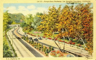
Sticking with SR 11 though, you'll notice that even through we're pre-110, we've got the Arroyo Seco Parkway designated on the map, which had just opened that year! I love driving the Parkway, even if the people coming on from a full stop sure is terrifying. 
That postcard I found online shows what it would have looked like back in 1941. Same sentiment as today, completely different execution. Now back to the Harbor Parkway (later Freeway). The first southward headed portion opened May 14th, 1954, and then it slowly pushed toward the harbor. It took until 1962 to reach PCH (SR 1). 1970 saw it reach it's current completion, as well as the opening of the Vincent Thomas Bridge. 

So an elevated road to downtown was just a concept back when this map was printed in 1941. SR 11 along an expanded Figueroa was the best way to go from the harbor to downtown. No idea how frequent stops were on this road. Certainly there was much less development in 1941. 

In case Marine Stadium catches your eye like it did mine, that was build for the 1934 Olympic rowing events. Hollywood Park and Turf club is there off Manchester, but LAX looks a little too far inland, touching Hawthorne Ave. (now Blvd.)

The map shows Loyola University, but not Marymount. Not sure when those schools combined. University of California at Los Angeles, love it. 

Carson wasn't a city yet, but we've got incorporated Lomita, Harbor City, Long Beach, and Compton. Note how font size tries to convey city size, Long Beach and Compton are much bigger than say Wilmington. 

Walteria is listed as it's own city, that's now been annexed by Torrance. That's enough for now. 


Pacific Electric Railway

Many thanks to www.erha.org for the info in this post.

San Pedro was recently awarded the USS Iowa and it is simultaneously being touted as the boon the Queen Mary has been to Long Beach, and the burden it has been to Long Beach. One of the side projects that has been discussed along with bringing in the ship is connecting it to the historic Red Line in San Pedro. San Pedro reopened some of their Red Line tracks in 2003, because, well, if it worked for San Francisco, it could work for San Pedro.

The execution is similar to SF. While SF's historic streetcars go up Market from it's genesis in the Castro up to the hotels downtown and out to the wharf, San Pedro goes from the Cruise Center to downtown, Ports of Call, and the Marina. It's just a 1.5 mile trek, designed to take those who just came in from or are about to go out on cruises to some of San Pedro's hot spots.

Of course, the original Red Line was much more extensive. We've got a map to prove it!


You can see the San Pedro terminal on the map, and the extension of the track that currently carries the historic Red Cars that you can ride today! I'm going to assume that little jaunt along what's called Wilmington Road on the map is the line Banning built. The Red Line was founded by oil man and real estate tycoon Henry Huntington of Huntington Beach and the Huntington Library. 

I've always been told that the Long Beach - Los Angeles line was the first of the Red Lines. And, the current metro Blue Line follows many of the same rails, the elevated parts excluded, of course.  It was at least the first conceived and executed by Huntington, I guess the Pasadena lines were partly found art. 

Look at this photo: 

On American Avenue, Long Beach
please don't super sue me Metro Transportation Library and Archive
That's what was then known as American Avenue, which is where the Long Beach line heads south toward the water through downtown Long Beach. The photo is from 1955, after buses replaced the rails on American Avenue. Then in 1959 they changed AA to Long Beach Blvd. And of course, later they reopened the Blue Line on LBB, using the old rails.

I do love an old kodachrome photograph. Anyhow, up past Long Beach, the train went through Dominguez, Compton, and Watts (as it still does today). Anyhow, take a look at the map, and see what details stand out to you.


Thursday, September 15, 2011

What's in a name?

Looking at an LA Times infographic, which is mostly talking about the names of the various original land grants and who certain streets were named after. It includes the Pueblo de los Angeles 4 sg Spanish leagues grant, the San Pedro grant, and the Los Palos Verdes grant I talked about last time.

It mentions that Carson St. was named for John Carson, a descendant of Juan Dominguez. John Carson was instrumental in developing what became the city of Caron in 1968. Sepulveda, they claim, is named after Francisco Sepulveda who was an interim mayor that built a house on Olvera St.

In 1839, Francisco Sepulveda was given the San Vicente y Santa Monica grant by the Spanish government in recognition of his services to the crown.. This along with Rancho San Jose de Buenos Ayres was annexed in 1916 as the Westgate addition, about 48 acres. Sepulveda's son was given Rancho San Joaquin, which he sold in 1864 to James Irvine (uh huh) to pay off some debts. He also purchased Rancho Santiago de Santa Ana, another OC holding that contained present day Santa Ana, but lost it later.

I can't find anything about when Sepulveda blvd was laid down, but there's a little bit about the man and his family, and how instrumental they were in LA's founding. Sepulveda also had an investment in the development of the San Pedro port property.

Ever wanted to know a bit about Beverly Hills history? Why we pronounce Rodeo drive the way we do? The Franklin, Coldwater, and Benedict canyon runoff met at about Beverly dr. and Sepulveda. This grant of land was known as Rodeo de las Aguas or gathering of the waters. Maria Rita Valdez de Villa was given this grant by the Spanish in 1838.

The grant was regranted after the California Land Act of 1851, then sold in 1854. Many different attempts at development were made, but eventually it ended up in the Rodeo Land and Water Co. who developed it as Beverly Hills, after Beverly Farms, Mass. The city of Beverly Hills is almost entirely intact from this original grant. It's proximity to Hollywood made it a great place for the stars who made big bucks to build houses.


LA Expansion History


Another map. This one shows the history of Los Angeles annexations and land purchases up until 1916. A lot of cool details in this map. California became a state September 9th, 1850, but the cession treaty treaty with Mexico was signed in 1848. So it shouldn't be a surprise that LA was incorporated April 4th, 1850, a few months before CA became an actual state. The original borders of LA were just 4 sq Spanish leagues. That grant was signed back in 1781 by the Spanish crown. BTW, 4 sq Spanish leagues is apparently 28.01 square miles. So that's a pretty big square.

There were two southern extensions, and one western, before 1900. Also added before 1900, Highland Park and Garvanza. Garvana was named for the Garbanzo beans that used to grow there (delicious hummus), and everyone knows Highland Park. Also just before the turn of the century was the annexation of land being used by USC.

However, after all that land grabbing became the moment which begat the area I've been focusing on. In 1906, LA annexed a 18 square mile shoestring of land leading down to the port. Then on August 28, 1909, LA consolidated the cities of Wilmington and San Pedro.

Jose Dominguez was a Spanish soldier, who was granted a tract of land for cattle grazing. The grant in 1784 was seventeen Spanish leagues, much bigger than LA. After the cession, Dominguez' grant was rehonored by President James Buchanan in 1858, but the land was disputed between the Dominguez and Sepulveda families. Dominguez got a Cal State University named after them, Sepulveda got the road outside my house that follows the coast up to the valley.

But seriously, apparently in 1882 the land was divided up into seventeen parcels, two of which must have been the already existing cities of Wilmington and San Pedro. Wilmington was founded in 1858 by Phineas Banning (what a great founder name, he got a High School) who named the town after his hometown in Delaware. He was a transportation and shipping magnate.

The declaration of San Pedro as a foreign port of entry with its own customhouse to collect tariffs came from Washington DC, and Banning made preparations. He built the breakwater, a railroad, and dredged the harbor. There were also naval develops in the area going way back.

Anyhow, this is all to say, the story is not LA saw potential in the harbor and jumped on it. Fifty years of work was done at the harbor with money from three families, and LA scrambled to buy the Shoestring Addition to make the city contiguous, and then consolidated with San Pedro and Wilmington.

Hollywood is the only other city listed on the map as consolidated, in 1910. One month after that consolidation, D.W. Griffith would make the first film in Hollywood, called "In Old California". There's a great book called "American Lightning" that delves into the history of this event, how films struggled to gain legitimacy in New York, how LA was this anti-union town, and how the LA Times building was bombed.

The map also shows LA's largest annexation, the 1915 addition of the San Fernando valley. This also comes up in American Lightning, as well as the movie Chinatown. The purchasing of water from the Owen Valley to irrigate San Fernando desert and build homes on it, making millions off the sale of land to this new immigrants to Los Angeles.

Anyhow, those are just things that came to me, I was inspired to look up, etc, by looking at an old map. Pretty cool, huh : )

Wednesday, September 14, 2011

Palos Verdes Estates

This map took me longer than I care to mention to put together. It's of the Palos Verdes Peninsula, in the 60s I believe, when there were only two cities incorporated on the hill; Palos Verdes Estates and Rolling Hills. The map was provided to my grandmother back in the day by the PV Estates Chamber of Commerce, and there are still to this day some cool shops where that star is. 

PV Estates was incorporated back in 1930, a completely planned community designed to invoke ranch life within driving distance of downtown Los Angeles. You can see ALT. 101 at the top right of the map, that's what PCH used be called, now it's Highway 1. That top right is where you go down off the hill to Lomita and Torrance. 

Back in the day, PV was serviced by the Rolling Hills telephone exchange, which used the call FRontier 7, which I think is pretty cool. FRontier 1-7 covers much of what Redondo and Hermosa Beach can touch. If you live by the beach on that South Bay curve and your house has a 37x number, you have one of the original phone numbers. 

St. John Fisher, the catholic church up there, 377. The catholic churches are a good landmark because there's one in every city down in LA, and they're old, and they don't change a lot.  

Anyhow, back to the map, there's a lot of cool little details. You got Marineland down on Portuguese Bend, Marineland was the first aquarium to ever capture a Pacific Orca. That Orca died two days in captivity, but Marineland's best success was Corky. She was able to give birth to the first Orca calf born in captivity. Corky was later moved to SeaWorld after the park bought Marineland and now performers under the stage name....oh what is it? Oh yeah, SHAMU.

All the streets in PV Estates are Via something, the planers works hard to give it that little Spanish village feel that the lawyers go crazy for. you can see that it's largely undeveloped. That's another one of the features of PV. Even today, there are horse tracks next to most of the roads, hardly any streetlights, and many residents keeps horses, goats, chickens, and all sorts of wildlife on their property. 


More Telephone Exchanges

Family dinner tonight. My dad mentioned that his phone number growing up in Inglewood was ORchard something something, which is consistent with what I've learned about the Inglewood phone exchange.

My grandma said something with a TH or a TR, my memory is already fading. I'm thinking it's Thomwall, which would have been the Vernon or Central LA exchange. Which is about right. My grandma grew up near enough to old LA Wrigley Field. I'm sure at some point I'll write a post about the old minor league LA Angels.

I looked at the church I went to growing up, in Lomita. Lomita was DAvenport 5 and 6, and sure enough, the Church's phone number is 326. It's amazing how it all starts to fall into place when you look at the history. I've got an old Palos Verdes map coming up in a second, which is why I'm moving us over from Carson to Lomita. Someone tell the girl at the switchboard we need to place a call one town over.

Address

The post address is a fairly straightforward thing to break down. LA's grid extends all the way to San Pedro, and Main St. (later Wilmington, past Lomita) is the East-West dividing line, and 101 freeway kind of dividing things North-South.

So in Carson, since that's my focal point, going South on Main you'll see 223xx between 223rd and 224th. and so on. I used to work in an Ice Cream shop in a shopping center on Sepulveda at Main, and our adress was 1xx E. Sepulveda. Twenty some miles from downtown and on the same grid structure. Amazing! My house is on a N-S street, but I won't say between which two numbers, since I decided to make this blog semi-public.

Our house is in a cul-de-sac, separated by an alley from other E-W streets of the same name, and by train tracks from other N-W streets. A true true dead end. The street names in the area are really all over the place, we got named after a Spanish beach town. We're an avenue, which is supposed to be a broad, tree lined road, and we had Jacaranda Trees before my dad led a tree chopping revolution. Now we have a magnolia. It's sort of a shame, as the Jacaranda is a tropical American tree, with a lot of local history, and the Magnolia is an ornamental imported from the old world.

The City, well not much to say. Carson was incorporated 1959, it's mostly a residential community built around the 110 freeway, the 405, and the 91. Torrance is the closest major city, there's a small shopping mall and a city hall built off the 405, and the Home Depot Center built off the 91.

Zip Code. The 9 narrows it down to California, Oregon, Washington, Hawaii and Alaska. 900 is Los Angeles, 907 is Long Beach, 45 is our postal zone. As far as I can tell, in the old Postal Zone breakdown, Long Beach had it's own numbering system but we were too far west. And we were well south of the end of the LA postal zone. As far as I can tell, Torrance didn't have postal zones set up. But perhaps time will turn up something.

Area codes (redux)

I'm gonna post this here so it doesn't get lost. Berkowit made a good point over on TBLA:

Probably when they started running out of area codes with 1 in the middle (only 64 of those available, if the outer digits had to range 2-9) they had to find another way to let the system know when you were going to be dialing a 10-digit number. Starting with a is that very clever way. It could only mean “area code follows, then number”. So you could now use 0s in area codes.
It totally makes sense. So you tell everyone they have to use 1 before the area code in 1990, then you can create 310 (South Bay-LA), 510 (East Bay-SF) etc. and the server knows that it's going to be a ten digit number. He also mentions this:
When you first start dialing, the phone system doesn’t know how many digits you’re going to end up dialing. But, in the early days, they must have chosen area codes that could not be used as exchanges anywhere so the phone system would know after 2 or 3 digits if it was area code (expect 10 digits) or not (expect 7 digits). Using “1” as the middle number of an area code would facilitate that, since 1 could not be either first or second number of an exchange (dating from the old days which required letters – no letter for 1 or 0 on phones). 


Area Code

213 used to be the area code for all of LA County. All states with multiple area codes were given 1 as the middle number, so that's that. The 2 and the 3 are specific to identifying Los Angeles. In fact, originally 213 covered all of Southern California. It was one of three area codes created for california in 1947. Then everything South and East of LA was cut out to form 714 in 1951, and then the northern counties were cut in 1957.

213 covered all of LA county until the 818 was created in '84 for the valley, and the 310 in '91 for the South Bay. Apparently the 310 only could be made because we had to start dialing 1 before making a long distance call.

The important bit is that when this house was built in the 50s, the phone # would have been 213-834-xxxx. Possibly it was 833 or some such before the 4 line was added. In fact, when we bought this house in 1990 it still would have been 213, not until the next year did we become 310.

Another note about the original numbers. They were doled out by population, the denser the population the lower the number you got. New York 212, Los Angeles 213. Because everyone had rotary phones, the idea was to give more people fewer dial pulls, and vice versa.

Having lived in LA and San Francisco, I've lived in two of the original California Area codes, which I think is kind of neat. The other original left is Sacramento.

My phone number

Hello me. This is a place for me to investigate into all the nuances of my life, the history of them. Or at least that's a launching point. I don't expect to ever make this a public blog, this is just a place to put all the little history research projects I do.

For example, a poster on TBLA got me thinking today about phone numbers. I have a cell phone now, but that number is largely meaningless to me, in that it's not grounded in a place. The number I've known for as long as I can remember is the land line at my parent's house in Carson.

(310)834-xxxx

I've always known those numbers meant something, but I never really dove into it until today. The 310 means the Santa Monica Bay area code. I'll look more into that later. What I want to focus on is the 834 part. I learned today that 83 corresponds to two different areas in LA County. VErmont ave in Culver City, and TErminal island down in the South Bay. So the 83 refers to a telephone exchange in San Pedro.

The old San Pedro exchange was built by Southern California Telephone Company, to provide Harbor Area service. Carson being an unincorporated area north of Wilmington (Port Town) at the time, this makes sense. The building today has SBC signage, and I guess probably AT&T now. TErminal had exchanged 1,2 and 3. The four must have been a digital exchange added later.

I assume SCTC was bought by Pac Bell, which was bought by SBC, which merged with AT&T. Now to look into area codes.

Update:
I overlooked something. My house was never served by the San Pedro Exchange. Carson lies between Compton and San Pedro. In the 1940s SCTC built an exchange in Wilmington to relieve San Pedo from Wilmington and South Carson. They took up the TErminal exchanges 0,4 and 5! So 834 refers to the Wilmington exchange, not San Pedro. Wilmington also took over some exchanges from Compton as North Carson was populated in the late 1950s, the SPruce 5 lines (775).

It's weird, I actually live in an older house than my Grandparents do, which you don't expect. Their Harbor City number doesn't seem to correspond to anything, nor does my cousin in Hawthorne.