Thursday, March 29, 2012

Carthay Circle Theater

One piece of history I've been dying to write about, but haven't yet because so many others seemed to already be on the case, is the Carthay Circle Theater. Right now it's a buzz worthy historical item because Disney's California Adventure is building a replica as part of their remodel set to open June 15th. It's been written about by Disney Parks, and KCET so what could little old me really add? Well, I'm gonna do it anyhow.

To give you a greater historical scope, Disney's California Adventure already has a Hollywood Blvd (with Hollywood Golden Age era facades) that meets up with Sunset Blvd (where the Tower of Terror sits), and a centerpiece theater called the Hyperion, with a facade meant to invoke the old Los Angeles Theater on Broadway.

What they're adding is the Carthay Circle Theater with a small plaza in front, and a stretch of road that will be known as Buena Vista St. That street will also have 1920s inspired storefronts. To connect it all, California Adventure is bringing back the Red Car, just like San Pedro did on it's waterfront.

Fox Carthay Circle on the night of a premier, photo credit LAPL

The Fox Carthay Circle held many premiers in it's day, with bleachers set up so fans could see the various stars arrive. My grandmother has told me stories about being taken to the Carthay Circle by her older relations to see such an event. The Carthay Circle sat on San Vicente between Wilshire and Olympic (not too far from LACMA, West Los Angeles) until it was demolished in 1969 to build an office park. 

Carthay Circle 2012, Disney's California Adventure, photo credit Josie Becker

Luckily for this amateur historian, the theater is reborn in 2012, standing tall in California Adventure. So just what is the theater's significance to Disney? Well in 1937 it hosted the premier of Snow White, Disney's first feature length film. 

Snow White original run poster

If you look at the Disney Parks article linked above, they have another really neat poster, a photo of the crowd awaiting the premier at Carthay Circle Theater, the playbill, just all sorts of neat stuff. It was a record setting event. The theater had 1,518 seats that sold out for $5 a pop (that's $79.05 in today's money) at a record pace, and 30k gathered outside just to see what was going on. 

The film grossed $8.5 million ($134,384,409.72 in today's money) at a cost of $1.4 million (a nice profit) giving Disney the power to make classics such as Pinocchio, Dumbo, and Bambi in the 40s. The enthusiasm about the film, as well as requests for some sort of studio tour, led Disney to begin planning what would eventually become Disneyland. 

An early Disney attempt at giving fans an attraction where they could live the films. 

Of course, it wouldn't be the Disneyland way to simply stick Carthay Circle in the middle of a modern world. Buena Vista St. and the return of the Red Car will do much to try and transport visitors back to the world of the 1930s (minus the war in Europe and terrible affects of the Great Depression of course). Disney Parks Blog wrote about the return of the Red Car yesterday (link). 

The Pacific Electric Red Cars in the wild, headed to Santa Monica.

Before the abundance of freeways, these trolleys were the dominant mode of transportation in Los Angeles. Santa Monica Blvd. had a median in the middle for two sets of tracks (as seen here and in the KCET article). The trains picture in that photo were part of the West Hollywood line, KCET has written about how West Hollywood grew out of a rail yard town named Sherman. Sunset Junction, another key figure in the Gay Rights struggle, also takes it's name from the Red Car system (also via KCET)

So if you go to California Adventure this summer to check out the new Cars Land be sure to give some love to the time that launched the Disney corporation. I know it's what I'm excited about. And as a bonus, here are the costumes that will be worn by Cast Members assigned to this area; as shown at an Annual Passport holder preview. This could also be labeled, Disney goes into my closet. 


Sunday, February 19, 2012

Los Angeles Angeles of Anaheim, California

As I've tried to illustrate on this blog before, baseball didn't begin in Los Angeles with the Dodgers and Angels. There was 50 years of baseball history in LA before the Dodgers arrived, from the Cubs holding Spring Training on Catalina Island, to the Wrigley family investing in the Los Angeles Angels. The Angels played (and thrived) at Wrigley Field in South Central LA. They had competition from the cross town Hollywood Stars who played in West LA.

I've yet to venture into Orange County on this blog, so my first venture across county lines is going to be about baseball and a whole lot more. It's probably not surprising that Orange County was once a part of Los Angeles County, divided off in 1889. The 213 area code used to stretch all the way to the Mexican border, until a flash cut in 1951 created the 714 for Orange and San Diego Counties.

Philadelphia Athletics in Anaheim for Spring Training

Los Angeles had Wrigley Field (1925) and Gilmore Field (1939), and not only did these facilites house Pacific Coast League teams, but they hosted Spring Training for major league teams. The Chicago Cubs and New York Giants both spent Spring Training time in Los Angeles, with the Cubs building a permanent facility on Catalina. 

At the same time Gilmore Field was opening, Anaheim opened it's first baseball stadium: La Palma Park Stadium. At the intersection of Harbor and La Palma ave, the stadium was built to house Anaheim's entry in the newly founded California League. 

There had been several attempts to start a California league since the turn of the century. The California State League of 1899-1902 was affected by the National Agreement between the National and American Leagues. Six franchises, including the LA Angels, broke off to form the Pacific Coast League which fell under the National Agreement.

In 1941, the current California League was formed with franchises in Anaheim, Riverside, Bakersfield, and Santa Barbara to name a few. The Anaheim team was known as the Anaheim Aces and played at La Palma Park. It's a small park (it still stands), which held just 3504 spectators when it opened. 

The Aces only lasted one year, but they weren't the only team to use the park. The Philadelphia Athletics held Spring Training there from 1940-42. You can see in the photo, they were a hit with the local ladies. 

World War II forced the Athletics to not come back. Anaheim would try minor league baseball again in 1947 with the Anaheim Valencias, founding members of the short lived Class C Sunset League. 

Anaheim Valencias, 1947

The Valencias were actually successful, winning the Sunset League title in 1947. Their uniforms are obviously inspired by the Philadelphia Athletics who had held Spring Training there, and the oranges on the shoulder should be a clue that they were named after the Valencia oranges grown locally. In fact, the California Valencia Orange Show (a bit of a trade show for orange growers) was held at the site of La Palma Park Stadium in 1931.

That's a lot of oranges! (Photo courtesy Orange County Historical Society)

The Valencia's battled the Riverside Dons and the Ontario Orioles for two years, before television broadcasts of Major League games hurt attendance at minor league ballparks nationwide. The Valencias folded after the 1948 season. 

Professional organized baseball wouldn't return to Anaheim until 1965, but Anaheim would change forever in 1955. Walt Disney had been drawing Mickey Mouse shorts since 1928's Plane Crazy. In 1937 his first feature length cartoon Snow White premiered at the Carthay Circle Theater. 

Disney didn't invent the idea of the large fair, New York and San Francisco held large expositions, nor did he invent the large park (Griffith Park and Central Park were certainly inspirations. What Disney did was have the wherewithal to combine the two concepts with giving fans of his films something to visit (studio tours of an animation studio lacking a bit of pizzaz) creating Disneyland which opened in 1955. 

Disney bought 160 acres of orange groves and walnut trees in Anaheim, and spent $17 million on construction which took one year. The Santa Ana Freeway (then US 101, now I-5) was completed in 1956, linking Los Angeles with Disneyland directly. In fact, on this map (1958) the adress is listed as Santa Ana Freeway at Harbor Blvd. a sign of the changing (more suburban) nature of Los Angeles and Orange counties where address were relative to nearby freeways, instead of local cross streets.


That image and the upcoming images that inspired this triple entry (Orange County, Disneyland, and baseball) all come from Vintage Disneyland Tickets, a website I consider a must see for any LA history enthusiast. 

Dodger Stadium broke ground in 1959 on 352 acres costing $23 million to build (privately financed). It was built off the Pasadena Freeway, just south of the junction with the Santa Ana Freeway. It opened in 1962 and while it was built by the Dodger owner Walter O'Malley for the Dodgers, it would open with two tenants. 

The Dodgers moved to Los Angeles in 1958 after O'Malley purchased and moved the Los Angeles Angels. As the Brooklyn Dodgers, O'Malley sought a replacement for the aging Ebbets Field in Brooklyn. He wanted another site within the borough, but New York City official Robert Moses wanted to build the stadium in Queens on the site of a former World's Fair. 

Moses was a big proponent of freeways, and with his public funds was responsible for the Triborough Bridge and was just generally always in favor of car culture over public transportation. O'Malley wanted nothing to do with Queens, and came out west for a new beginning. Moses would eventually build his stadium, Shea Stadium, which became the home of the New York Mets in 1964. 

The New York Mets were an expansion franchise granted to the National League to replace the Dodgers and Giants who both left New York in 1958. They entered the league in 1962, paired with the Houston Colt 45s. The year before the American League had expanded, placing franchises in Washington and Los Angeles. 

The Washington franchise was a replacement for the Senators who had left for Minnesota. The LA franchise was the American League keeping pace with the westward heading National League. 

The Dodgers adopted the cap logo of the original LA Angeles, but the American League LA franchise owner Gene Autry paid the Dodgers to use the name. Since the original Angels had been moved elsewhere, the AL LA Angels moved into vacant Wrigley Field for the 1961 Season. 

While the Dodgers were playing in a cavernous football stadium (the LA Coliseum), the Angels were playing in the majors' smallest ballpark. It was only 340 to left field, and the Angels pilled up an then franchise record 240 home runs. 

When Dodger Stadium opened up in 1962, the LA Angels moved in though they called it Chavez Ravine. Gene Autry sought a stadium site in Los Angeles, even Long Beach. The City of Long Beach wanted them to be known as the Long Beach Angels, so that was nixed. The team ended up striking a deal with the City of Anaheim. 

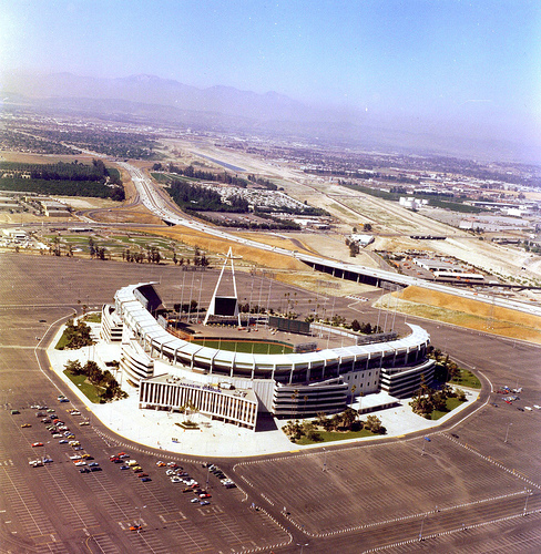
Anaheim Stadium 1977. The Orange Freeway in the background was finished in 1975.

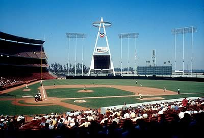
In contrast with Dodger Stadium, it was the City of Anaheim that financed Anaheim Stadium. It was built on 160 acres (same size as Disneyland) at $24 million. Like Disneyland it was built off the Santa Ana Freeway (Orange Freeway wasn't completed yet. Note the original home plate gate before Disney renovated it, and the Big A in the outfield holding up the scoreboard instead of a marquee by the freeway. It opened in 1966, at which point the team became the California Angels, with an interlocking C-A instead of L-A in the original logo.


With all of that as background we get to the item which inspired today's post. In 1967, the California Angels' second year in Anaheim Stadium, a deal was offered where one could purchase tickets for a doubleheader. For the low price of $5.00 each, fans would get a ticket in the reserve level at Anaheim Stadium to watch the Angels take on the Cleveland Indians at 3:00pm on Saturday. They would then have access from 8pm to 1am to a special party at Disneyland Park. 


The 3:00 start is interesting. In England, soccer matches traditionally started at 3:00 because that was just after the factories closed on Saturdays. At Disneyland patrons would have access to all attractions without the need for individual tickets. It really was quite the deal. And it represents the symbiotic marketing of the Angels and Disneyland which still happens today. 

On the back is a complete Angels schedule. Night games (8:00 starts) are designated with light bulbs. You can see that day games usually start a 1:00pm, so the doubleheader start time was a special deal. There was also a twinight start with first pitch at 6:00. Now most every MLB game starts at 7:00pm. 

Anaheim Stadium from the inside, 1966. 


There are also a number of scheduled doubleheaders. And look at that, Anaheim Stadium was granted the All Star Game in just it's second year of existence. The LA Coliseum would host the All-Star Game one year after the Dodgers moved to LA, but Dodger Stadium wouldn't host an All-Star game until 1980 (and hasn't since). Part of that is just a result of baseball's rapid expansion in this time period, meaning plenty of new stadiums to work into the rotation (and revisiting some classics) not to mention the rise of the NFL leading to multipurpose stadiums being built in many cities. 

So there you have it, a brief history of baseball in Anaheim and Disneyland Park, and how it all came together in 1967. 

*Updated to correct dates, and to add photos of Anaheim Stadium. 

Wednesday, February 8, 2012

Broadway Theater and Commercial District

After reading about the restoration of Clifton's Cafeteria on broadway, and learning that it's part of a greater Broadway restoration project, I was intrigued enough to dive into a topic that I've flirted with a few times before. This restoration project defines the Broadway Theater district as Broadway between 2nd and Olympic. This includes 12 different movie palaces. 

Outside of Clifton's Cafeteria, celebration of the end of the second great war. Photo credit: LAPL


Olympic blvd was formerly 10th st. downtown, so that's an 8 block stretch with 12 theaters. Fun fact, it was renamed after the 1932 Olympics, the 10th rendition of the games.

I've written in the past about Lowe's State Theater (Broadway and 7th) but the Warner, Paramount, and RKO faced Hill St and aren't part of the redevelopment. I also used a photo I took of the Million Dollar Theater (Broadway and 3rd) used in (500) Days of Summer. That leaves ten other theaters I didn't know about : )

Broadway was originally Fort St., part of the original 1849 grid, and was renamed in 1890. The first theaters to crop up on Broadway were vaudeville houses in the early 1900s. The Orpheum and Pantages were part of their owner's respective theater chains. Pantages opened a theater in 1910 (now the Arcade Theater at 5th and Broadway), and then the original Orpheum opened up in 1911 (now the Palace Theater at 6th and Broadway).  

Vaudeville wasn't the only game in town, the Cameo would open in 1910 as a nickelodeon seating 775 people. Seven years later the Rialto Theater would open, giving Broadway two vaudeville theaters and two nickelodeons. There was also a traditional theater house in the Globe Theater (originally the Morosco) opened in 1913.

Million Dollar Theater with original marquee and facade. Photo credit: LAPL


By the end of the decade two movie palaces had opened up, the Million Dollar Theater in 1918 and the United Artists in 1919. The Million Dollar Theater was Sid Grauman's first project and the northernmost of the Broadway Theaters.

As the movie industry took of in the 1920s, Lowe's opened the State Theater in 1921 which could handle both movies and live vaudeville. In 1927 the Tower Theater opened. It was the first theater designed by S. Charles Lee, and the first theater in Los Angeles equipped for talkies.

Los Angeles Theater with City Lights on the marquee. Photo credit: LAPL


Lee also designed the Los Angeles Theater which opened in 1931. One of the grandest movie palaces ever built, it opened with Charlie Chaplin's City Lights. It featured an electric monitor of available seats,  neon floor lights, a restaurant, playroom, soundproof cry rooms, smoking room with built in cigarette lighters, and a lounge that featured a second screen which showed the film via a series of mirrors and prisms. The toilet stalls were marble!

The Roxie was the final theater to open in 1932. However, theaters weren't the only thing that cropped up on Broadway. As anyone who's been to a mall knows, a theater draws a crowd and where there are crowds department stores will open.

The first born of these department stores took it's name from the street, The Broadway. The Broadway would grow into one of Southern California's dominant department store chains, before most of them were sold off and became Macy's. Bullocks, May Company, and the 5th St. Store also sprung up along Broadway.

The entire Broadway Commercial and Theater district has been declared a National Historic Place, as well as the Bradbury Building and Million Dollar Theater.

Like many of the great things of the Roaring 20s, it was the Great Depression that stopped development on Broadway. After World War II as the freeways sent Angelenos out to the suburbs and suburban malls and theaters opened up, the Broadway district began to decay.

The restoration of Clifton's Cafeteria, which opened in 1916, is a positive sign that the revitalization initiative is making progress. Known for their charitable donations and "pay what you can" policy, keeping this type of place which has meant so much for so many generations alive is key in any community. So huzzah to the Broadway revitalization project. Huzzah.

Thursday, January 26, 2012

Scottsdale Estates: When Planned Communities Go Wrong

As a kid, I may have mentioned this before, one of my obsessions was the video game Sim City. I'll be honest, it was also often an obsession as an adult. I was fine at all the things the tutorial covered: setting down a working grid, and building a flat city. What I never could work out is a dense city center, with adequate transportation in and out to really get job creation (and home buying) flowing.

Part of that may have been my Los Angeles upbringing. When traffic began to congest, as it will, my first move was always to go to freeways. Big footprint, expensive to build, funds depleting freeways. And that's where my city always fell apart.

What I'm beginning to realize, thanks in large part to this excellent series on KCET.org, is that LA was no deferent than New York, DC, or San Francisco in it's early development. Railroads were crucial in that early development, and scars through the grid such as Santa Monica, Sunset, San Vicente, and Venice are all just following those early rail lines headed downtown.

Perhaps because I failed so often at Sim City, that development of railroads and roads, residential and commercial lots, has been enough of an obsession to lead me to start blogging about it. Specifically, I was curious about the area directly around my childhood home, which didn't seem to come up in these history articles.

Recently, I watched the movie Gone in 60 Seconds, the original shot in 1974. That version had a 40 minute chase scene that begins in Long Beach, tears through Carson and Torrance before finally culminating at a familiar looking car wash. From the moment Eleanor pulled off the 110 freeway at Sepulveda showing the empty lot where Target now stands, I knew a blog entry was a comin'.

Going up Avalon, Elanor passes by the Scottsdale Estates townhouses. The townhouses were built in 1964 as one of first So Cal gated communities. There were 600 town homes built on 40 acres along Avalon Blvd. There was a central pool, parks, ball fields, and a playground.

Photo credit: Gerano Molina, LA Times


However, by the 80s, it was better known for gangs and drugs. It now has highest crime rate in Carson. The pool has been filled in, there are bars on windows, and some parks are off limits after dark. Homeowners have always been required to pay dues, that fund is controlled by a 15 member board. The central clubhouse, now protected by armed guard, opens out to ball field at the center of complex.

In the movie, the then mayor of Carson is seen at a press conference on an empty lot, praising it's future development and the tax incentives which would encourage even more development. So what happened to the Scottsdale Estates?

It's probably fair to say that as a gated community it had an extreme suburban hive mind, especially with the required member fees. Like the families of rail workers or miners that formed so many of the turn of the century US communities, most of those living in the estates likely worked at the nearby Oil refinery; Carson's largest employer.

Economic downturn leads to people being laid off, after the oil crisis of the 70s. All it would take is a few members getting laid off, a corrupt counsel or two, plus the secluded nature of the parks (perfect for the drug trade) to lead to a community starting to eat itself alive.

It's unfortunate that my last two articles are about Carson development going wrong, especially since there examples of how development in Carson has go right. On the one had, in a house built in the 50s, it's interesting to think of just how undeveloped everything was around this trac at the time.

On the other hand, the blight of southern Carson is disappointing. Of course, that could easily be said of  everything south of LA and East of the beach communities. Riding the train from Long Beach to Pasadena yesterday, it was striking just how impoverished those communities along one of the original red car lines are.

Of course, development isn't a science. Factories close for just about any reason. But Carson's two main employers (the BP plant, and Northrop Gunman) are both going through hard times. It seems likely that things in Carson are going to get worse before they get better.  

Monday, December 19, 2011

More Oil!

The last time I sat down to write on this blog, it was due to a series of coincidences that made me want to better understand Union Oil. Attending a party on top of what used to be the Standard Oil building and watching Daniel Day Lewis play an oil man in There Will Be Blood a few days later led me to look into Union's pipeline to Wilmington, the huge oil refinery (and it's orange Jack-o-Lantern), and the series of high rises Union owned downtown.

Well as usually happens on the LA History blog, that initial oil entry has led to another. More oil! This time, it's an oil story that's been sitting underneath my feet.

My earliest curiosity on this blog, what the digits in our phone number meant, led me to discover this housing tract was one of the original developments in what came to be known as Carson. Built in the mid-fifties, we were given a phone number from the Wilmington branch of the phone company. That branch had been spun off from the original San Pedro branch, and thus San Pedro, Wilmington, and Carson all have 83x-xxxx phone numbers.

As cul-de-sacs go, ours is truly the deadest. Not only is there only one way in and one way out, we have a virtual moat around the development. On the South side of a major thoroughfare, we've got what used to be a can factory to the West, to the East is an alley separating us from the next development, and to the South are the railroad tracks of the BNSF Harbor Subdivision.

The Harbor Subdivision was originally built to connect downtown to Port Ballona in Playa Del Rey. Then when Redondo Beach built a better port, it was extended there. This is all pre-1900. Those two ports would be eclipsed by Los Angeles building it's own port in San Pedro, but the line continued to be useful in the 1920s because of the oil fields in the South Bay. So the line that was jutting out to the ocean curls back in through Torrance, through my back yard, and on into Wilmington and Long Beach. The line makes a giant crescent through western Los Angeles county.

On the other side of the Harbor Subdivision railroad tracks is the much larger Carousel housing tract, a 50 acre development built twenty years later. The owner of that property for the 50 years before the development was Shell Oil.

Wooden tank farm in Signal Hill, 1920s. These tank farms were all over the South Bay after the oil fields and refineries cropped up. Some still stand. Others, like the one on the property south of my house, were developed into housing as 


Now not only are oil refineries just something I grew up with, but tank farms are as well. There's still a tank farm on Crenshaw and Lomita Blvd, across from the Torrance Crossroads development and not too far from Torrance Airport. Their used to be a spur from the Harbor line called the Torrance Oil line that went from the airport, past the tank farm, and onto the Harbor line. I went to school down the street at the Catholic church.

I've now learned their used to be a tank farm just south of my house. It became an issue when owners of homes in the Carousel tract had ooze bubbling up in their yards. Shell had built the tank farm in the 20s, and it was basically giant concrete bathtubs with wood roofs. The old Shell refinery still stands 1.5 miles to the East (along Wilmington blvd) though it is now owned by BP. That refinery has the capacity for processing 266,000 barrels per day.

The Shell crude oil holding facility just on the other side of the train tracks, was sold to the developer as is, and it was the developer's job to clean up. Well that didn't happen, and cases of cancer in humans and adults on the tract are abnormally high. Ground water tests have shown serious amounts of methane gas and benzine. There are 285 homes in the Carousel tract.

When the pipelines were built out here, and the oil fields were discovered in Wilmington and Signal Hill, there weren't that many regulations. Techniques were, well crude. Not only is oil (be it through refineries, tank farms, and derricks in residential neighborhoods) still a major part of South Bay life, but the areas where conversion has been tried haven't always been successful. It's easy to see the link between some areas of the South Bay, and the angry townsfolk who were had by Daniel Plainsview.

Sources:
http://articles.latimes.com/2010/apr/27/local/la-me-carousel-shell-20100427
http://ci.carson.ca.us/MeetingAgendas/AgendaPacket/MG51973/AS51986/AS51990/AI52017/DO52081/DO_52081.PDF
http://en.wikipedia.org/wiki/Harbor_Subdivision
http://articles.latimes.com/1988-09-22/local/me-3068_1_medical-offices
http://articles.latimes.com/1991-03-21/local/me-693_1_torrance-crossroads
http://www.bloomberg.com/news/2011-02-09/shell-bp-to-close-sell-oil-refineries-in-europe-u-s-table-.html
http://blogs.kqed.org/ourxperience/2011/06/03/carson-residents-fight-shell-oil/

Monday, November 28, 2011

Oil!

Two weeks ago, Major League Soccer had it's championship game - The MLS Cup. As a beat reporter for the LA Galaxy, one of the teams in the Cup, I got to go a bunch of MLS sponsored events, including a rooftop party in Downtown LA. The Standard is a luxury hotel with a rooftop bar and beer garden, a part of a chain of similar hotels. 


Not a very inspiring building, built in 1955 as an office and headquarters for the Superior Oil Company. It's a functional high rise, an impressive height for 55 and showing a coming architectural trend of function over form.

The architect was Claud Beelman, who also designed the Eastern Columbia Building and the Garfield Building downtown. He has several buildings listed on the National Register of Historical Places. However, this isn't going to be a post about architecture. 

I happened to catch There Will Be Blood a few days after, and was intrigued by Southern California's oil history. Superior Oil seems to be a latecomer if they built their headquarters in '55, but Union Oil and Standard Oil were here since the turn of the century. In the movie an oil field under Signal Hill is referenced, and the Huntington family made their money on oil. Anyhow, it seems a subject ripe for digging into, so let's go ahead and do so. 

The Union Oil company was founded in Santa Paula, CA. Their headquarters in Santa Paula is a National Historic Landmark, but they only used it for ten years, between 1890 and 1900. At the turn of the century, they moved to Los Angeles.

When they came in 1900 they only needed one room, in the 312 Tajo Building at first and Broadway. The company had to move three times as they kept expanding. Eventually they moved into their own building. 


The Union Oil headquarters from 1911 to 1923 was the Bartlett Building in the Spring Street Financial District. At the base of the Bartlett Building were the Rush Drug Co., Hull's Grill, and Lamar's. It's a 14 story building, and when it was completed in 1911 it was the tallest building downtown. 

So what happened about 1910 that made Union Oil such a big player? They made a deal with the Independent Producers Agency, a group of small oil producers, to build pipelines from Kern County to Union's oil facilities on the Pacific Coast. This was the historical event fictionalized in There Will Be Blood, and I'm assuming was recounted in Upton Sinclair's book Oil! which the movie was based on and lends its title to this post. 

Before that deal, the Independent Producers had to pay high shipping costs to send their oil back east via railroad, and then take low prices per barrel from Standard Oil. Suddenly, so many lines from There Will Be Blood make sense! 

"So Standard offered us a million dollars for the Little Boston leases, and I told H. M. Tilford where he could shove that, and we made a deal with Union! On the pipeline! And that whole ocean of oil underneath our fields!" 
So what's the union in Union oil? That would be the union of small oil companies owned by Wallace Hardison, Lyman Stewart, and Thomas R. Bard. Hardison was born in Maine, and followed his brother to the oil fields of Western Pennsylvania. That area became the home base of John Rockefeller and Standard Oil. If this was a Pennsylvania history blog, that'd be a segway into the Rockefellers and all their contributions to that part of the country.

But we're about LA history, and the important thing to note is that because Rockefeller controlled the Pennsylvania oil fields, that drove a lot of oil men out to Southern California to prospect. Oil was discovered in Santa Paula in 1883. Hardison came out with Lyman Stewart, and their original company was called Hardison & Steward Oil Co.

Stewart's contribution to society is funding the publication of The Fundamentals, which became the holy book of the Fundamentalist Christian movement.

The third member of their union was Republican Senator Thomas Bard. He assisted in the formation of Ventura County, officially split from Santa Barbara County in 1873. He also helped build the town of Port Hueneme.

So the three of them form Union Oil and they become an alternative to Standard Oil for the California independent oil prospectors after the pipeline is built from Kern County. With regards to that pipeline, the discovery well of the Kern River Oil Field was dug by hand in 1899. It's the fifth largest oil field in America.

Huge discovery wells, Union Oil pipelines, gee this is all sounding familiar. Kern was originally a mining area, which isn't surprising as many of the early oil men used mining techniques and hoped to get lucky. When I saw the Kern oil field was dug by hand, before the pipeline workers really would just dump oil into big holes until it could be barreled and shipped.

Now, Union Oil was established 1890, and then Standard Oil entered California in 1900. At that time Union and six other companies had all been flourishing in California for around a decade or so. Standard was founded in 1870, so it's likely that the Kern field is what got them to come out to California.

Union was Standard's biggest competitor, especially after the 1910 oil pipeline. I keep mentioning that pipeline, and that it went to the Pacific Ocean, but I haven't said where it went. Well any resident of Wilmington or San Pedro should be able to tell you about the oil refineries down by the port. Union Oil built their 200 acre refinery in 1916 in Wilmington, then four years later built a four acre site at the harbor for receiving and shipping oil.

That birds eye view of the harbor shows the gigantic campus of the Wilmington Refinery in the forefront. While the campus is in Wilmington, most San Pedro residents know of it as the Great Pumpkin. Since 1952, the refinery has painted one of its three million gallon storage tanks as a big Jack-O-Lantern. Local kids can go down on Halloween to see it up close and get candy corn.


Here we've got a couple of workers looking at a model of the refinery. These days, the refinery has been split between three different oil companies. That's how gigantic the campus is! 


You can see the new Union Oil Building on the left there in the picture, it's the one with the sign reading Union Oil Bldg. There's also a Bullocks in front of that. This is looking south on Hill Street, as it crosses 7th Street. Or looking North. But that's definitely Hill St. 

The 12 story building was necessary for a company for $100,000,000 at the time according to the LA Times. It was designed by, wait for it, Claud Beelman. However, this one didn't make the Historical Register of places. Funny how all of this started with a party, and still all the connections can be made, yeah? 

Union's greatest achievement was the discovery of the oil field in Santa Fe Springs in 1919, which really put the company on the map. The biggest oil field in Los Angeles wouldn't be found until 1932 in Wilmington, which is the third largest oil field in America behind Purdhoe Bay, Alaska and the East Texas Oil Fields. 

That's enough ink spilt about the oil spilt in Southern California. As always, I've only scratched the surface and I'm sure I'll be inspired for more entries to come. Now I know how a rooftop party, There Will Be Blood, and a oil tank painted like a pumpkin are all connected. 


Monday, November 7, 2011

Googie Restaurants In Los Angeles

Since this blog has started to center around buildings and maps, I've had to invest energy in understanding architecture and cartography. I'm sure we'll get back to maps at some point, but right now it's all about buildings. Architecture plays such a role in the "history by sight" that I've been doing on this blog, but that also requires me to be able to identify different types of architecture. Which I can't do.

I can do some research into architectural periods, so I can at least fake it. For instance there was a classical revival known as Beaux-Arts that hit America in the late nineteenth century and influenced many buildings on the Berkeley campus. Given that it's called the Coliseum, I'd lump Memorial Coliseum in the Beaux-Arts category, with it's peristyles. The USC campus, however, fits more into the Art Deco style that was big through the roaring 20s. Then there was Streamline Moderne that influenced the Pan Pacific Auditorium, and finally the movement we're going to get into today - Googie.

Beaux-Arts and Art Deco were about building impressive, long lasting structures, things get simpler and sleeker in Streamline Moderne. What I understand about Googie is that it's designed to catch your eye, to engage in non-verbal communication with this new beast - the automobile driver.

I've been making a lot of noise these last few weeks of how cool downtown used to be with its theater district. Even in those pieces, I had to concede the separate theater district in Hollywood, and the suburban theaters popping up all over the landscape. Los Angeles transitioned quickly, like blink and you miss it quickly, from a centralized city to a bunch of suburban hubs connected by a central concept.

Much like Downtown and Hollywood, these suburban commercial centers had theaters, department stores, restaurants, and coffee shops. The idea with Googie was to develop consistant and striking signage and architecture to make a restaurant instantly recognizable. Some of these restaurants are still operating, like Pann's in West LA.


I was lucky enough to eat at Pann's this past weekend, and it's definitely a treat. It's gotten new coats of paint, but otherwise it's the same place the opened back in 1958. It's got everything I want from a California 50's diner: rock walls, angular architecture, and a fun Jet Age sign. 


That's the other big component of Googie. We're going to space! We're going to have flying cars and jet packs! Let's build a Space Needle and a Theme Building at the airport! Of course, LA and Seattle were super on board with the moment, as they had the large aerospace industry that I'm gonna have to write about someday. 

We snagged some original menus from Pann's take a look at this: 


The prices can be deceiving. That De Luxe Dreemburger adjusted for inflation costs $9.03, for a 1/2 of beef that sounds about right for a restaurant burger. The 1/4 pound Dreemburger costs $6.28. 

The half spring chicken is all fried chicken, and is still the centerpiece of their menu today. So naturally it's what I ordered. Good food, and it all cost less than the $13.74 the inflation calculator says it should be. 

That family night special actually sounds like a great deal. It's the same chicken meal, but without soup. I had clam chowder with my meal, and by the chicken got there I was too full to really make a go of it. 


The family that owns and still operates Pann's has quite a Los Angeles restaurant history. George Poulos (truncated for extreme Greekness, the original family name is Panagopoulos) learned to cook in the military, then in '47 at The Pantry downtown. He first managed a restaurant at Yum Burger on Manchester blvd across from Inglewood High School. The Poulos family finally opened Pann's in 1958. 


Of course, '58 is fairly late for a style that dates back to 1949. That's when the Bob's Big Boy in Burbank opened up, the home of the Double Decker burger (which is also quite tasty). In 1951 you have examples with Johnie's Coffee Shop on Wilshire, and the first Norm's restaurant. Which leads me to my next example (which I've also eaten at).


Downey is home to a lot of restaurant history, with the oldest standing McDonalds and the original Taco Bell. It also boasts this great Googie treasure, Bob's Big Boy once Johnie's Broiler once Harvey's Broiler. Harvey's (then Johnie's then Big Boy) opened in 1958, the same year as Pann's. Now Johnie's shouldn't be confused with the Johnie's downtown, but it is a great coincidence. It's possible they were under the same ownership, but I can only find circumstantial evidence of that. It's convincing circumstantial evidence though. That S curved arrow in the Johnie's Coffee Shop photo is also in the Johnie's broiler parking lot, and they're spelled the same which is an irregular spelling for Johnny. 


Many of the same great features as Pann's, big circular booths, rock walls. They filmed part of an episode of Mad Men there, when Don and his kids are in California and Bobby spills the milkshake. Filmed part of Pulp Fiction at Pann's (as well as the now gone Holly's). 

Johnie's was just one of the great coffee shops, operated as a restaurant up until 2001. By the time I was in high school and driving around, they were selling cars on the property. It was declared a landmark, then illegally torn down. Bob's Big Boy, who at one point had declared bankruptcy, bought the property and rebuilt it to the original specifications, but with the Bob's signage. 

Anyhow, that's a quick look at a couple suburban Googie restaurants I've had to fortune of dining in. 50's diners like Johnny Rockets always end up looking like midwest Streamline Moderne 40s diners playing music from the 60s. Shades of the restaurant in Back to the Future, I imagine. When I think 1950s, I think Googie, and the quirky little coffee shops it begat. 

***Update***

Seems I missed an important point when I first wrote this article. It's not just that Pann's and the original Norms, and Johnie's Coffee Shop all look like each other, they were all designed by the same firm. At the time the firm was known as Armet & Davis. John Lautner is the architect who designed the coffee shop Googie's which coined the term for this architectural style, but Armet & Davis have quite a few landmarks to their credit. 

Johnie's Wilshire was the first of their biggest contribution block to Googie architecture. That place was commissioned in 1955, in '56 they designed three restaurants in the LAX area; Pann's, Holly's, and Falcon Coffee Shop. 


This original menu is probably the closest we'll get to seeing Holly's, which has been demolished and is now an autozone. Holly's and Pann's almost feel like sister restaurants, don't they? We know they used the same architect, but their menus look like they were designed by the same person, and both menus feature a Dreemburger. Why ee? I don't know if I'll ever get an answer to that question. 

Holly's offered their Dreemburger for 45c to Pann's 80c, so clearly Pann's was the higher end option in area eats. Holly's also offers a Dreemburger De Luxe, like Pann's, but also 35c cheaper. The biggest difference I see in the menus is Holly's doesn't offer a chicken dinner, they're strictly steaks. 

If you click on the menu, you can see the devil in the details. Holly's has the rock wall, and plenty of light from the all glass front. It's longer than Panns, so instead of a square with a triangle hat, it looks more like a rectangle with a triangle flourish on the end. 

We'll be here forever if I try and show every building Armet & Davis designed, but their next building was the original Norm's in West Hollywood. However, now you know about the four really cool restaurants they designed before the ubiquitous Norm's.